
Throughout the county these days – from Glendora to Torrance, Sylmar to Norwalk, Whittier to West Hollywood – discussions are being held that will shape the future of transportation in Los Angeles. Along with the tens of billions of dollars voters approved for mass transit have come a brigade of yet-unanswered questions regarding the best way to maximize benefits from these new investments.
And nowhere is the conversation proceeding in a more uncertain direction than in the southeastern cities which are intended to be served one day by a rail line connecting downtown Los Angeles and the city of Artesia. The Artesia line has been paraded by the agency’s Office of Extraordinary Innovation as a target for private investment and trumpeted by Mayor Eric Garcetti as a project that will be open by the time the 2028 Olympics hit town. So the clock is ticking, potential funders are milling about, and the only problem is… well, Metro has no idea what route this line will eventually follow -particularly in downtown Los Angeles.
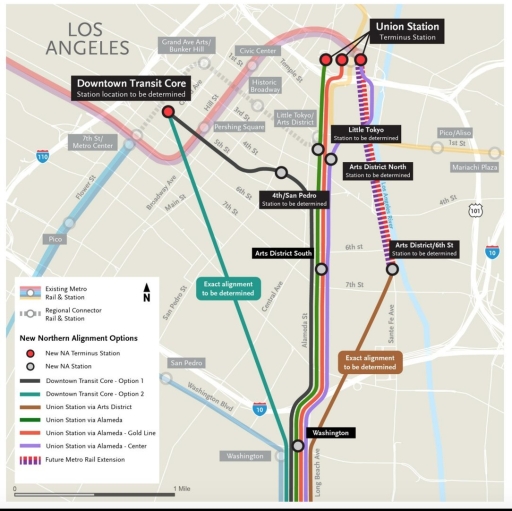
After last year’s scoping period for the project failed to yield a consensus, or even a firm grounding of approval, staff is hurriedly preparing six new alternatives for the northern section of the route, to complement the six it already had.
The new ones are being presented on Wednesday to the Planning and Programming Committee despite being less than fully fleshed out. One is little more than a diagonal line with “To Be Determined” attached. Nonetheless, they are a likely to be included for study in the environmental review process, as a result of the exceptionally fractious politics of the project, which in all honesty probably warrants its own post. For now, I’m going to look at the new alternatives and their potential implications for the quality of the overall transit line.
Two things stick out in the new alignments:
- Metro is now considering routes that bypass Union Station, with routes that veer either east to the Arts District or west into the downtown core
- All of the new routes begin at the current Washington station, meaning the Pacific Boulevard alternatives, favored by many in southeast Los Angeles for their station serving the industrial job center of Vernon, appear to be falling out of favor.
The Case for Bypassing Union Station
Let’s start with the first point, since avoiding Union Station is counterintuitive to many Angelenos. After all, it’s the rail hub of Southern California, a landmark, almost synonymous with the region’s rail heritage. But – and this is important – it’s also a total mess.
Shoved in the armpit of two concrete rivers, nestled next to the largest prison complex in the entire country, Union Station will never be anything but a place to make transfers. There’s nothing wrong with that, except that transferring at the station is also fraught.
This diagram from Metro’s Union Station Master Plan illustrates how the station evolved with the arrival of the Red and Gold Lines in 1993 and 2003, respectively. The underlying layout of the station has remained the same since the streetcar days, but more and more services have been squeezed into the margins. The result is challenging transfers like the one from the subway to the Gold Line, or from anything to the Silver Line.


Maybe there are remedies to this, but the clearest one is to stop trying to shoehorn local transit services into LAUS.
In the face of a solid bloc of downtown stakeholders opposing any route on Alameda that’s not below-grade, and a request from government agencies that the West Santa Ana Branch not run through the Union Station railyard, Metro still offers three new routes that end at the station. According to the report, station locations include, “underground west of Union Station; underground west of Metro Gold Line platform; and at-grade east of Metro Gold Line platform.”
The first two options would mean that there would be a subway station at the level of the subway’s mezzanine, something like 700 to 900 feet away from the Red and Purple Lines. Connections to the railyard and bus bays would be even more belabored. We should really stop and think what we’re trying to accomplish by tacking another disjointed transfer here.
Where light rail is concerned, Union Station offers only the pretense of good connectivity; it can’t deliver more. The only remaining space at the station would result in transfers of such poor quality that it would be best to avoid Union Station if there’s any hope of making better line-to-line connections elsewhere.
As it so happens, the new alternatives do provide us that possibility.
Serving the Downtown Core
The Downtown Transit Core option 1 alternative as depicted here is revelatory. It is a major break with the agency’s typically conservative approach, presenting an ambitious, forward-looking alternative for the Artesia Line. The most logical elaboration of the sketched alignment would cover 2.8 miles from Washington station north on Alameda to 4th, which it would then follow west into the heart of the Financial District.
With 7th blocked by the subway, 4th Street (or 5th in a pinch) is the ideal corridor for providing service through downtown. Fourth aligns with the Pershing Square subway station as well as potential stations at 6th and Santa Fe and the infill 4th/5th and Flower station of the Regional Connector. Beyond downtown, it lines up with possible extensions to Glendale via Glendale Boulevard, to West Hollywood via Beverly and Santa Monica Boulevards, and to Whittier via Whittier and Washington Boulevards.
Those potential routes are beyond the scope of the initial West Santa Ana Branch project to be sure, but the corridor represents what should be an aspirational goal in Metro’s planning: fast, high-quality connections today, and the possibility of rational extensions in the future.
With respect to those connections, the Downtown Transit Core 1 alternative hits all the must-haves. It connects to the Blue Line, to the subway at Pershing Square, and to the Regional Connector at Flower. It also would spread the congestion currently concentrated at 7th/Metro across three stations, helping to assure the long time stability of the downtown area transit network.
What to Make of the Other Alternatives
Workable solutions could be made from either of the other two alternatives, though it would be less easy. DTC-2 is barely more than a sketch, but, if the premise turning toward downtown before hitting 4th or 5th, that leaves few options: 1) following 9th Street over to Pico station; 2) following 9th Street and then heading north toward 4th; 3) taking 7th.
I really don’t regard 7th Street as a legitimate option here. Following 7th all the way west would require a 3rd level underneath 7th and Metro, and unnecessarily dump tens of thousands of new passengers (locally-destined traffic, transfers to the Red, Purple, Blue and Expo Lines headed in all directions) on the system’s most crowded point.
Following 9th to Pico seems similarly lackluster, more or less duplicating the Blue Line on Washington, and, even worse, failing to connect with the subway at all, resulting in yet another crush of passengers transferring to the Red and Purple Lines at 7th Street.
Ending the line in the Arts District near 6th and Santa Fe would probably be the alternative that would make the most people angry. The area, though it’s getting media heat for real estate development, remains isolated. A terminus here would serve no purpose but to feed trainloads of passengers to the subway, while simultaneously necessitating (and almost single-handedly justifying) the acceleration of the construction of the Arts District’s pet project.
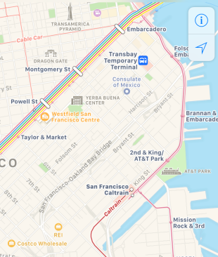
Like the not-dissimilar setup at 4th and King in San Francisco, the Arts District would be a temporary solution at best, requiring some eventual continuance of the line into the main business district and beyond. But the east-sheering Arts District route works against the need to go west.
This isn’t a common occurrence in Metro’s history. As planning progresses across the county, many lines (Van Nuys, Whittier, Crenshaw) are under constant threat of degrading into boondoggles hamstrung by failures to think far enough ahead. In this instance, Metro has admirably taken community feedback and turned it into an opportunity to improve a major capital project. All that remains to be seen is whether they can follow through.

If elevated on Alameda to LAUS isn’t in the cards, might as well go underground to Pershing Square and the financial district.
LikeLiked by 1 person
The historic core route proposals are clear a step in the right direction, but they miss the mark. While a route on 4th or 5th street would serve underserved corners of the core ( namely the “wedge,” my name for the area between Los Angeles and Alameda streets, caught between the built-up downtown core and the arts district and encompassing the thriving wholesale and fashion districts) and connect to existing subways, transposing the line a couple blocks south magnifies these benefits. Veering off Alameda at 7th would still be direct but would be more central to the Wedge, in closer proximity to its largest destinations like Santee Alley and southern parts of the Broadway Corridor/Historic core which are just outside the 7th/metro or pico station walkable distance. At Spring, the line could gradually jog north for a station under Wilshire, to connect to and be an extension of 7th/metro, twice as many transfers as Pershing (assuming TBM technology can burrow under existing cut & cover tunnel boxes). Here, I made a map for the potential alignment, and station boxes (and a potential extension north) https://drive.google.com/open?id=17_zvp9HOHnsrPFfT29AnOfpWM2ndR9tf&usp=sharing
LikeLike
Also, win the Regional Connector completion and Union Station turnback, along with the addition of another exit for surface-bound passengers, congestion at 7th/metro will foreseeable be greatly reduced
LikeLike
What do you mean by another surface exit? The one at the Bloc?
Congestion at 7th won’t be reduced, unless the Purple Line is a flop. The Regional Connector will increase the usefulness of light rail in the inner ring suburbs of the east side (not only Boyle Heights, but also Lincoln Park and Highland Park). Stations in those neighborhoods should see increased demand relative to slower bus service. But the regional connector’s main benefit in terms of congestion is eliminating the transfer for passengers whose trip ends in the financial district or who need to transfer from the Gold Line to the Blue/Expo Lines.
The latter group is small compared to the number that would be expected to transfer from *any* light rail line to the Red or Purple Lines. Unfortunately that transfer is much more likely to take place at 7th than anywhere else. The Regional Connector actually makes bypassing Union station very convenient for most passengers.
LikeLike
I support a route west into Downtown along 7th, 8th or 9th Street, connecting at 7th/Metro. 7th/Metro provides the only transfer you need – to all central HRT and LRT lines. And a stop at Broadway or Spring Street is essential, to serve the lower Historic Core and the Fashion District.
Mittim80’s diagram shows how it can be done. I envision the westbound route crossing over the Red Line up to Wilshire/Grand, and then under the Blue Line at Wilshire/Flower, and continuing west under Wilshire.
To those saying 7th/Metro would be too crowded, I would point to the MANY rail stations around the world which safely accommodate far more passengers and transfers than 7th/Metro will ever see. Metro just needs to apply bold, creative design to the passageways and portals, to make transfers easy and entering/exiting safe and user-friendly.
LikeLike